10 October 2019

Aire 2: Shipley to Airmyn

Day 2 of the River Aire ride featured a river under a railway station, a tale of three power plants, more reminders of the county’s cycling pre-eminence – and a lot of mud, both under my wheels and at the mouth of the river. (Back to ← Day 1)


I was out bright and early along the canal, heading to Leeds, Yorkshire’s national capital. Wild horses clearly are not the sole preserve of Dartmoor or the New Forest (pic).


The sunshine was low and golden, and it was downhill all the way to Leeds (pic). The towpath is excellent, apart from a fraction of the time where it’s muddy, uneven and puddled. A fraction of about four-fifths.


Approaching the city, I was not alone. It was rush hour, and cyclists and walkers thronged the towpath (pic). Like the joggers, the canal and river run alongside each other.


The Aire thunders dramatically through the catacombs underneath Leeds railway station (pic). Venturing here used to be the preserve of urban explorers; now it’s busy with commuters toting takeaway coffees and explaining on mobiles why they’ll be late in.

The station interior has been remodelled too, and more than ever it’s Yorkshire’s closest glimpse of London, with a shiny concourse and lots of smart young people walking purposefully to the rhythm of money.


There’s now this entrance up from Granary Wharf basin (pic), over the Aire and directly up and into the southern platforms, making it easier than ever to arrive in good time to find Northern have cancelled your train.

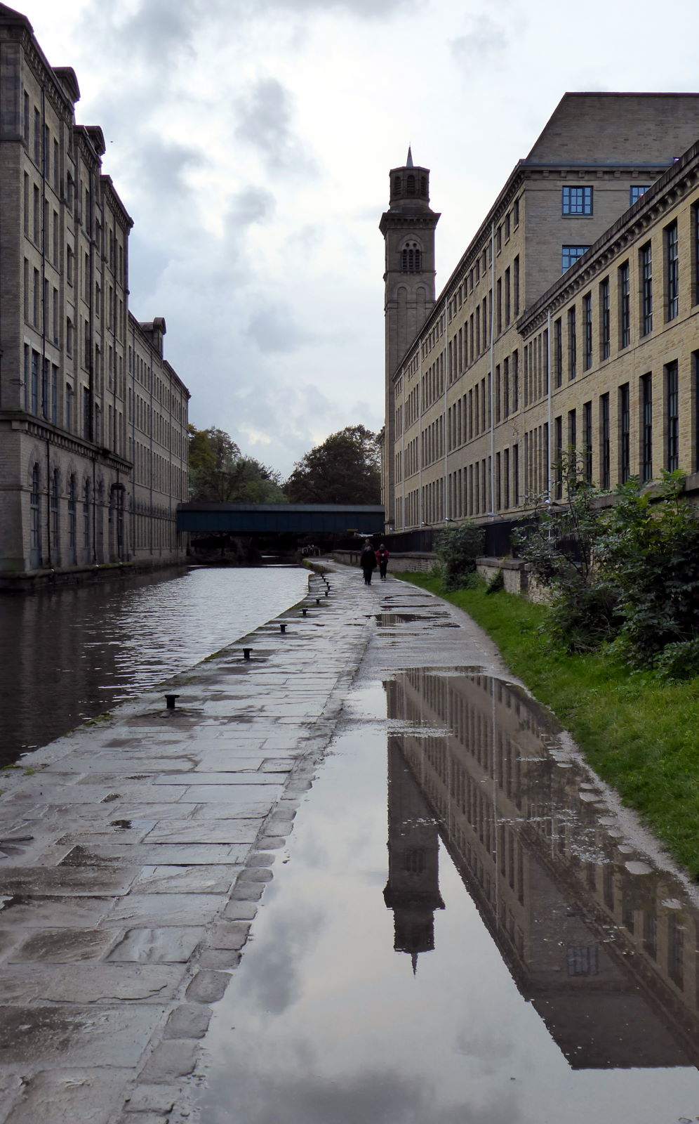
It’s here that the Leeds–Liverpool Canal ends, in Granary Wharf (pic).

There’s a water taxi from here to the Armouries: at a quid for the ten-minute journey it’s a great way of sightseeing Aireside Leeds, but getting a bike on would be impossible down the steps.

And anyway I had to go through the centre of town to find a Greggs bacon roll.


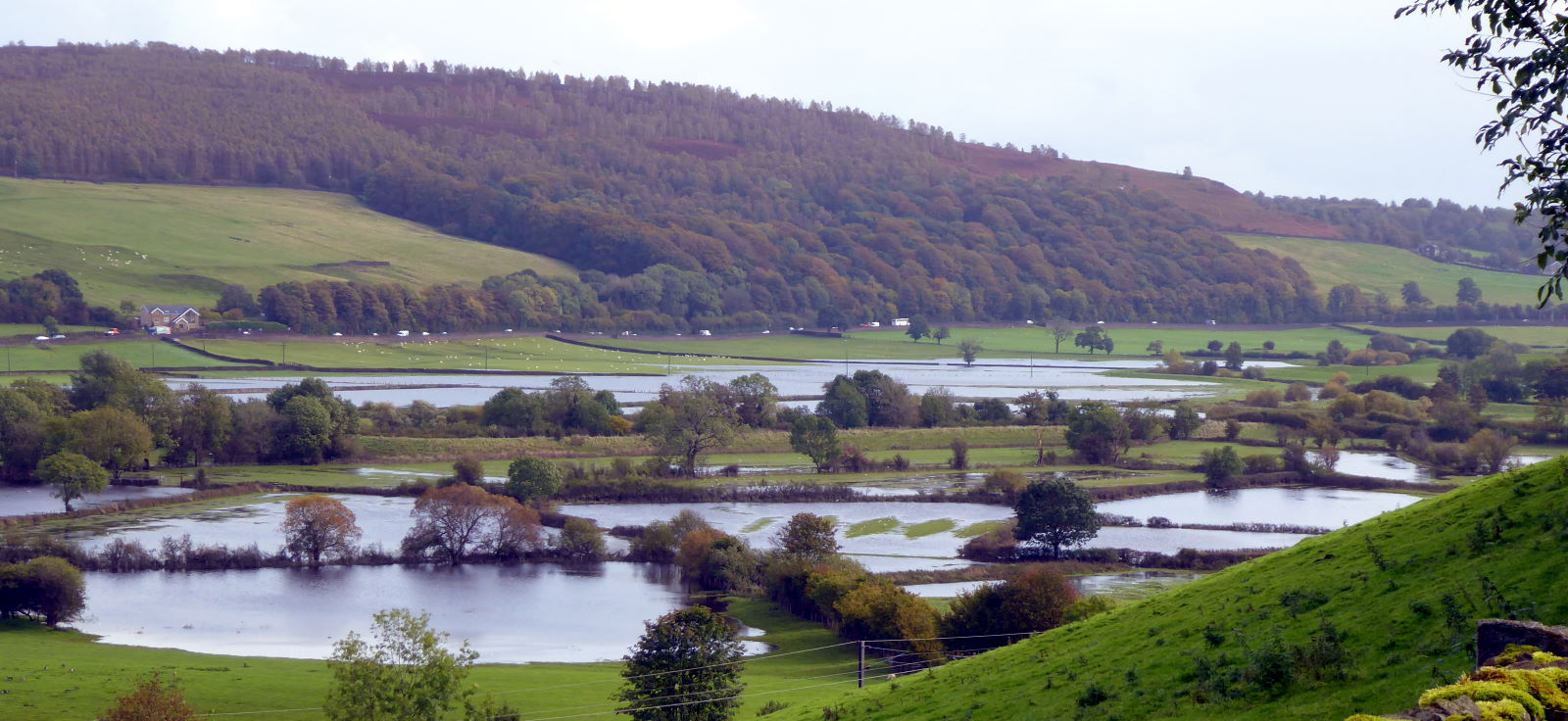
The view over the river from Leeds Dock is impressive (pic), and as you leave the city limits the towpath is in good nick. Then it’s back to mud and puddles. There’s also one slightly challenging bridge crossing with steep steps, but a little expertise in scrambling, abseiling, and perhaps dismantling your bike, will make it easier.

The Aire now runs parallel with the Aire and Calder Navigation, whose towpath forms part of the Trans Pennine Trail. It runs past the grand nature park of St Aidan’s, a former opencast mine. If mills were a feature of the upper Aire, heavy industry defined the flavour of the lower Aire from the 1800s to the 1970s. A flavour of sewage, industrial runoff, arsenic, cadmium, etc.

The water quality has improved massively since then, with fish returning to the river. We’ve spent hours in St Aidan’s once or twice in the past, most of it trying to find our way out. Those TPT signs can be pretty contradictory. Goodness knows how the fish find their way.


By dint of ignoring TPT signs and a long muddy snicket, I found my way to Castleford, which has a splendid curvy ped and cycle bridge over the Aire (pic) by the historic Queen’s Mill, once the biggest stonegrinding flour mill in the world. After nearly two days of cycling through mucky water, my bike’s drivetrain was doing a pretty good impression of grinding querns. And felt about as light.


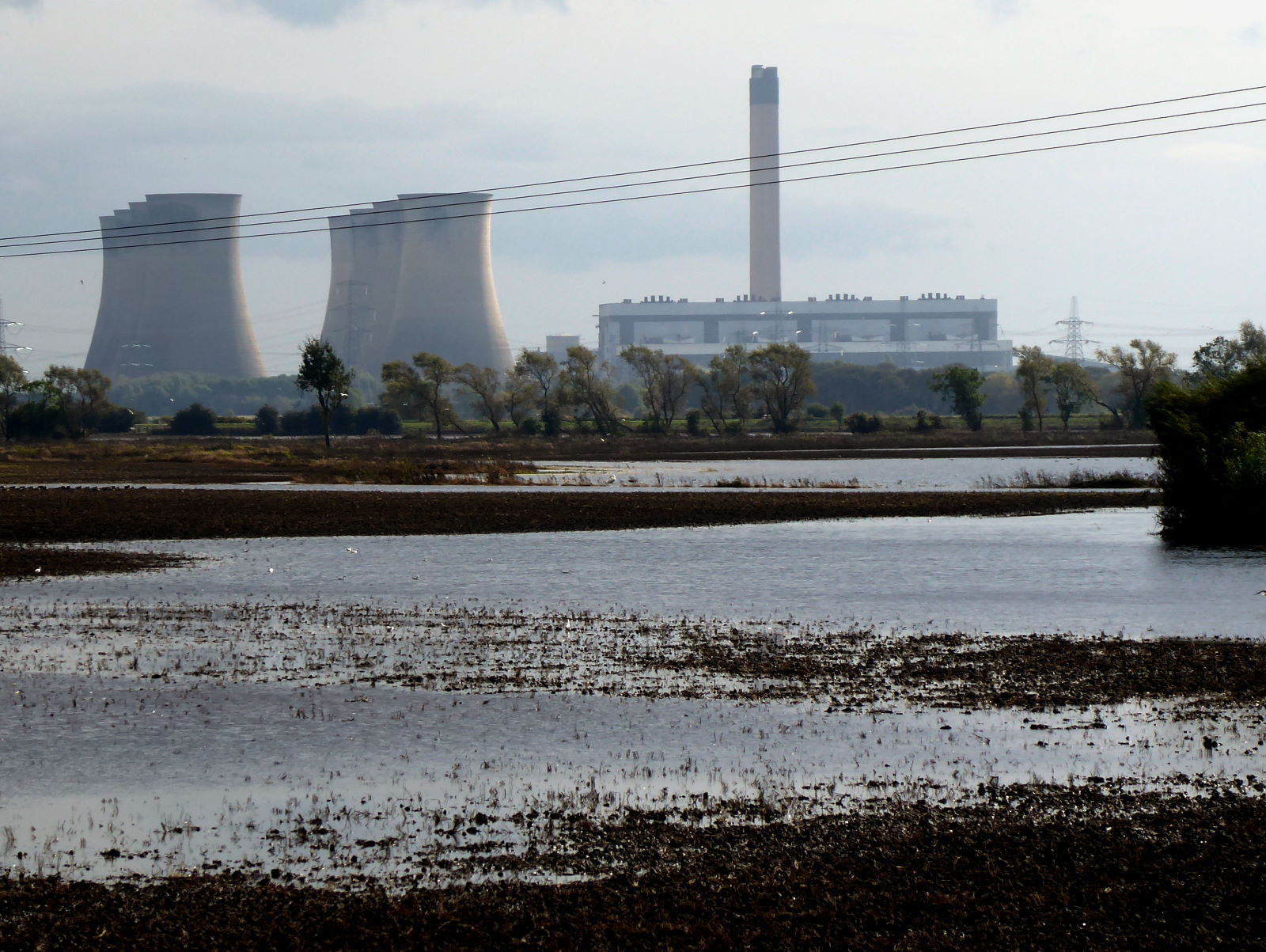
From here the Aire ‘valley’ spreads out into flatlands, the river starts meandering chaotically, and roads give only fleeting views of the waters. And for fans of hyperboloids, good news: the dominant sight now becomes cooling towers, forests of them, in the three huge power stations that sit on the lower Aire: Ferrybridge (pic), Eggborough, and Drax.


But not for long. Ferrybridge C (pic) set fire to its last chunk of coal in 2016. I passed just in time to see these cooling towers intact: four of them were demolished four days later. (Here's the BBC website report and video of it.)


Eggborough (pic) shuffled off into retirement in 2018, but Drax is still going, carrying on the traditional Yorkshire crafts of coal-fired power generation, pollution and unsustainable carbon emissions. Hmm; so much for the Northern Powerhouse.

I enjoyed trundling through the pleasant small towns of Snaith (with a fine church and a lavish number of pubs) and Rawcliffe (with a lovely, picnickable green and some nice frontage on to the Aire). I also had a big tailwind, which helped. So it wasn’t long before I rolled into Airmyn, on the river’s mouth – indeed, the suffix ‘-myn’ evidently is an old word for ‘-mouth’.


Airmyn is inspiringly enthusiastic about cycling: the entire riverside, in the Aire’s final stretch, is dotted with yellow and blue bikes (pic). It felt an appropriate end to my ride. Passing the handsome clock tower I passed a sign saying Please respect the welfare of the pigs by shutting the gate. Their well-being duly respected, I walked along a footpath to the end of the Aire and the very end of the trip.


This is the mouth, where the Aire joins the Ouse just north of Goole (pic). A suitably muddy but large-scale finish to Yorkshire’s most industrial river, and perhaps the one with most variety of sights. It’s a lake! It’s a river! It’s a canal! It disappears and comes back!

So, I cycled on to Howden, another fine town with a glorious minster and attached ruins, and enjoyed a pint brewed in Snaith for £3.10 before my train home.

Another very enjoyable rivers ride, and given the amount of bumpy offroad and towpath riding, I chose the perfect bike for it (my trekker, an adapted Scott MX1 MTB with front suspension and 42mm tyres). Once I’ve cleaned it I might remember what colour it’s supposed to be.

Miles today: 55
Miles in all: 100

Back to ← Day 1

09 October 2019

Aire 1: Malham to Shipley

River Aire

Source   Tarn Foot, Malham
Mouth   River Ouse, Airmyn
Length   92 miles
Towns   Skipton, Keighley, Shipley, Leeds, Castleford, Knottingley
Route   See on Ridewithgps

The fourth of my Rivers Rides was a splendid two-day, 100-mile trip from Yorkshire's one-lake Lake District to its three-power-station powerhouse along the River Aire. Day 1 featured England’s highest lake, a disappearing river, stunning canal scenery, floods, a fairy story, a World Heritage Site and a Wetherspoon. (On to Day 2 →)


This is the source of the Aire (pic): the glacial beauty of Malham Tarn, 377m up on the roof of some of the country’s most dramatic limestone scenery. Welcome to Yorkshire’s Lake District, even if there is only one lake. Yorkshire’s Titicaca, even if it’s a bit lower down.


It’s fed by springs running off the surrounding slopes (pic). It was remarkable to think, as I pedalled up the steep hill from Malham, that the drizzle which wasn’t working its way into my sandwiches would find its way into the tarn, and thence downward a hundred miles to the North Sea. How does it know where to go?


The Aire starts here – if not quite in name yet – at Tarn Foot, at the southern end of the lake (pic). But a few hundred metres later, a very strange thing happens...


...because it ducks under a wall (pic)...

...and dives down into a bed of nettles (pic).

And then, like a dodgy diplomat’s wife evading responsibility for a fatal driving accident, it just disappears.

So, from here I zoomed down the steep back lanes to the wondrous village of Malham, which I talk about in a previous post on this blog.

A couple of hundred metres south of Malham, along a boggy footpath, at a place entertainingly called Aire Head, another very strange thing happens...


...because, like a dodgy insurance fraudster canoeist turning up in Panama without a paddle, the Aire springs out of the ground (pic), all innocent like, 1500m south and 180m lower from where we last saw it. Where’s it been? What’s it been doing? Nobody knows.

At least we know that it is that same Aire which started out like butter wouldn’t melt back at the lake. That’s because, in the 19th century, they dammed Tarn Foot to see what would happen. Sure enough, Aire Head went very quiet, then – half an hour after the dam was removed – it gushed again.


Now the river gets going, winding its way down some fine dales scenery (pic). The cows are clearly rubbish meteorologists: all standing, yet it was a day of constant drizzly showers. With sunny intervals in between. One of those days when you simply can’t decide whether to be in or out of your rainjacket. Taking back control is an illusion. Yet another metaphor for Brexit.

Hauling myself from Bell Busk to Gargrave over Mark House Lane – described as a ‘bridleway’ on the OS map but perhaps more accurately called a ‘stream’ – I enjoyed seeing this rainbow (pic).

No crock of gold, but a crock of something else, thanks to the cow-friendly farmyard I’d mistakenly ridden through while getting my bearings.

At least the stream’s abundant waters washed my wheels and lower frame as I clattered down the track.


In Gargrave, I joined the towpath of the Leeds–Liverpool (pic), England’s longest single canal, which follows the Aire valley all the way to Yorkshire’s capital. They’re resurfacing it, though the stretch east between here and Skipton (and east from Skipton to Silsden) is still unmodified, bumpy mud.

Anyway, the towpath was closed for the refurb works for cyclists’ safety, but luckily there is an alternative, viz the busy, HGV-infested, semi-lethal A65.


Skipton (pic) is a handsome, likeable market town with a picturesque canal basin, lots of fish and chip shops, friendly locals who direct you when you get lost, and a superb statue of Fred Trueman, the greatest fast bowler who ever lived, in the opinion of experts such as Fred Trueman. Post-cricket, he made a successful career as a professional Yorkshireman.

I love the statue – it brilliantly evokes the man's delivery-stride swagger, momentum and poise. The work – by Yorkshire sculptor Graham Ibbeson – is one of the best examples of that modern thing of a statue celebrating the idol in action (see also Morecambe, Eric); not standing statically, like those mutton-chopped Victorian blokes, or menacing colonial generals.

The only thing it lacks is a speech bubble of Fred roaring, ‘Tha’s aat, Gunga Din. Get thissen back to t’ pavilion. Join me next week in Indoor League. Ah’ll sithee’.


From here to Silsden I avoided the quaggy towpath and followed minor roads along Airedale, which afforded splendid views of the scenery, and the flooded valley (pic). I went through roadwork signs outside Cononley saying ROAD CLOSED because, of course, you can always get through on a bike, and, of course, I could.

Several drivers ignored the signs too because, of course, they think the signs don’t apply to them, and, of course, they couldn’t.

I heard the drivers arguing in vain with the roadworks crew who all spoke with friendly but impenetrable Polish accents. Then I realised they were actually Scousers.


In Silsden I got back on the L–L towpath (pic), now surfaced, continuing its scenic paralleling of the Aire itself. Then it rained again and the towpath got muddy again. But I was on my trekking bike and I was happy.

Outside Bingley I enjoyed the sheer drop down Five Rise Locks (pic).

This is Britain’s most vertiginous stretch of towpath at 20%, and done rather quicker by bike than by boat.

Even uphill. Even me.


Bingley itself pleasantly surprised me, partly for its impressive weir where the Aire is bridged (pic), partly for its inviting and vibrant-looking main street shops.

Alas, I didn’t have time to stop, because I then diverted through Cottingley, intent on researching the village’s famously elusive real genuine authentically faked fairies, which I’ve blogged about separately.

A little further on is Saltaire, Titus Salt’s Victorian model village for the workers at his grand Aire-powered mills (pic), now a World Heritage Site.

The puddles are great for reflecting the austere grandeur of the mill buildings. They’re less great to keep cycling through.

The back streets of Salt’s model terraces commemorate family members and mill workers.

They charmingly recall names popular in Victorian times, such as Ada, Herbert, Amelia, Fanny, Albert, and Upper Mary.


Saltaire’s characterful houses (pic), top of the range for their time, were complemented by facilities such as bathhouses and a hospital. Titus wasn’t having any pubs, though. So what he’d have made of the Wetherspoon in neighbouring Shipley where I enjoyed a £2 post-ride pint or two is anyone’s guess.

It had been a very good day, with a wide range of scenery, sights and refreshment opportunities. As I sat on my comfy bed, post-shower, in my bargain single room in a modest Shipley hotel, I congratulated myself at how fresh and energetic I felt after forty-odd miles of mostly offroad, fairly strenuous cycling. Only half past seven, I thought: I could go out and have a night exploring Shipley’s pubs.

Instead I went to bed, one of many good decisions I made today, and fell asleep immediately.

Miles today: 45

On to Day 2 →

Cottingley: Fairy story

The suburban village of Cottingley, a few miles northwest of Bradford, is one of those placenames you can’t help mentally auto-completing. Ilkley Moor... Baht ’at; Piltdown... Man; Loch Ness... Monster.

And, thanks to capers by the stream in the back garden of this house (pic) in Main St, Cottingley... Fairies.

Because in the 1920s, after being published by the Strand magazine, photos of sprites dancing with two local girls down by Cottingley Beck went viral. They convinced many – including spiritualist Sir Arthur Conan Doyle – that here was evidence of the world beyond, rather than girlish mischief with paper, crayons and scissors.

They were not-very-deep fakes, of course: light-hearted hoaxes contrived in summer 1917 by Elsie Wright, then 16, and her cousin Frances Griffiths, 9.

Elsie, a talented artist who worked in a photographic studio and knew how to stage a good portrait, drew figures on card and propped them up with hatpins for the photoshoot to make her father smile.

(‘Fairies at the bottom of the garden’ was a phrase evidently in currency then: Rose Fyleman's poem of that title had just been published in Punch magazine.)

To the jaded 21st-century eye, as they were to Elsie’s dad, the photos are obvious phoneys. We live in a wiser age now, where nobody could be fooled by, say, anti-vax campaigns, flat-earthism, climate change denial or empty promises on the side of a bus.

Nevertheless, even though contemporary cynics pointed out the hairstyles were suspiciously human and fashionable for other-dimensional elfs, for decades the photos fooled the sort of people (including Elsie’s mum) who believe you when you tell them the word 'gullible' isn't in the Oxford English Dictionary.

The cousins, evidently embarrassed at the family jape taking on a life of its own, went along with the story and no doubt hoped it would all blow over and be forgotten. It didn’t and it wasn’t. Finally, in the 1980s, Elsie wearily fessed up.

By odd coincidence, the house is now owned by the graphic novel artist Luke Horsman, who was unaware of the house’s history of fantasy and pictorial artifice when he bought it.

Sadly, the only access to the beck is in the back gardens of houses of Main St and of the new housing estate nearby, making it hard for anyone wanting to re-enact the Great Fairy Photo Hoax. The only public glimpse of the watercourse is from a bridge (pic) on Lysander Way, in that new estate.


Also on the estate are Oberon Way (pic)...


...and Titania Close (pic): a Shakespeare fan and fairy devotee evidently had fun when choosing the street names one midsummer night).

However, that’s about all you’ll get for puckish sights in Cottingley. Main St has a barber and a hair stylist, which might offer pixie cuts I suppose, and the beauty salon could give you a daintily spriteful look, though not me. But fairy-themed specials from the fish and chip shop, Beckside Fisheries, are not on the menu. The local pub, the Sun Inn, seems to have closed down, so no pints of Fairy Liquid from any Cottingley Brewery.

If there were fairies with magic powers down by the beck, I think I know what wish locals would ask to be granted: to make the village’s crushing rush-hour traffic jams disappear. But, as everyone knows, fairies – and magic wands – don't exist. Especially in urban transport planning.