08 August 2020

Ure 2: Ripon to York

Day 2 of the River Ure ride featured a pig playing bagpipes, a mysterious automatic hand, devilish darts, Roman mosaics, ice-cream at a lock, and a celebration riverside pint in York. (Back to ← Day 1 • On to Day 3 →)

An easy day today, following the river down the flat Vale of York from Ripon’s market square (pic) to York itself.

We were in Ripon’s magnificent cathedral as soon as it opened (but well after Gregg’s had opened: I had their bacon roll deal).

It’s an awesome building of course, full of light and spirit, and the installation of a zillion paper cranes (pic) added something ethereal.

I assume they’ve had a fire risk assessment: living in York, we’re a bit touchy about naked flames and cathedrals.


Both of us were taken with this choir-stall carving of a pig playing bagpipes (pic), particularly its attentive audience. What comment is being made here is anyone’s guess.

Another item open to debate is this hand (pic) above the choir.

Apparently it’s some sort of mechanical conductor, perhaps pedal-operated by the organist to count the singers in?

Speaking as a former choral singer, I’ve had a few wooden conductors myself in my time.

The obvious way out of Ripon was along the canal (pic) this sunny morning...

...and we soon got to Boroughbridge’s bridge over the Ure with its surprisingly sylvan view (pic).


The town is clearly bike-friendly (pic) after serving as a significant venue in the 2014 Tour de France.

It’s also darts-friendly, thanks to the remarkable sight of three prehistoric monoliths, known as the ‘Devil’s Arrows’ (pic).

Needing just 27 to win, apparently Satan lost it, got banished to a pit for a thousand years and was thrown into a lake of fire.

Of course, he should have gone 11-double 8.


Next to Boroughbridge is Aldborough, once a Roman town of some note and wealth, as two decent-ish mosaics (pic) demonstrate. If anyone looks at my floor in 1800 years’ time they may find less to admire. Perhaps the stain of that dropped bottle of Malbec will have disappeared by then.

Quiet, lovely lanes took us through the Ouseburns, and to Ouse Gill Beck (pic).

Now, if you believe everything you’re told – and, having worked with Tory politicians and BBC journalists, that’s something I’d warn against – you’d say that the River Ure changes name to the Ouse here because this stream joins it.

That’s right: the Ure, a proper river, so wide it’s only road-bridged once between Boroughbridge and York, is supposedly renamed after a dribble of water that a three-year-old could jump across.

I simply don’t believe this. I suspect circular reasoning (the beck gave its name to the Ure because it used to be much more important, and it must have been more important because it gave its name to the Ure). And that the beck is named after the big river it flows into, not the other way round.
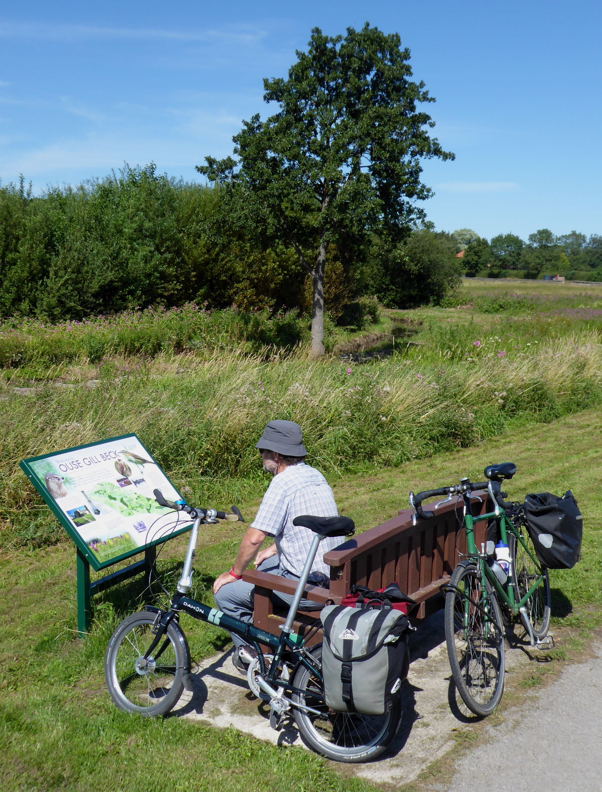
We read the information board’s pro-Ouse-Gill-Beck propaganda (pic).

I can believe that the Ure historically was called the Ouse after its confluence with the Swale. That’s at Swale Nab, a few miles upstream from Ouse Gill Beck’s invisible contribution; the place where Ure and Swale decide amicably to collaborate.

My previous ride ended there, and it’s hard to say which is the bigger river. It seems almost unfair to favour one of the names after they join forces; so why not a new name?

As a modern-day egalitarian, not some stuffy old imperialist believing the superior dominate the weak, the notion that the Swale and Ure work together to create something new, the Ouse, appeals to me.

So, in my book, or at least my blog, the Ouse is the continuation of the Ure (and its equally important partner the Swale).

Anyway, that single road crossing over the Ouse is Aldwark Bridge, a delightfully clanky old wooden toll bridge (pic).


I stopped halfway to take some snaps, and thought it would be nice to have some cyclists in the frame. I waited for these three to appear (pic), and saw to my surprise that, quite by coincidence, I knew one of them: Scott (right) was doing the 170-mile Way of the Roses, from Morecambe to Bridlington, for charity, in ten hours.

When I last did it, I took three and a half days. I was carrying a tent, though.


At Linton Locks the river, now swollen with the raging torrent of Ouse Gill Beck, has a broad weir and picturesque bend (pic)...


...and lock (pic) and, more interestingly for us, a cafe which served us and dozens of sunseekers with ice-cream. Actually most of the sunseekers were also swigging lager, but we preferred to wait until our finish at York for our pint reward.


The final stretch to York is one of the loveliest on the whole river: a cycle route runs right by the water for the last few miles (pic).

All familiar territory to me, of course. I live here and have done these bits dozens of times.

The Minster above the river is still a delightful sight on such a sunny day though (pic).


So I had the luxury of my own bed tonight, but Tim was heading back to Cambridge. So we celebrated our ride with a pint of Sam Smith’s at the only Ouseside pub opportunity in York, the King’s Arms (pic).

The reason why no other pubs are quite so keen to be right by the water becomes clear when the river is in flood...

Miles today: 44

Back to ← Day 1 • On to Day 3 →

07 August 2020

Ure 1: Garsdale to Ripon

River Ure

Source   Ure Head, Garsdale
Mouth   (as River Ouse*) Trent Falls, Faxfleet
Length   (inc Ouse*) 129 miles
Towns   Hawes, Masham, Ripon, Boroughbridge; (as Ouse*) York, Selby, Goole
Route   See on Ridewithgps

The eighth and last of my Rivers Rides was a splendid three-day, 130-mile trip from lofty moors to vast estuary along the River Ure. Day 1 featured Yorkshire’s Niagara, someone who couldn’t organise a drink in a brewery, a disappearing hornblower, and lots of grand dales scenery. (On to Day 2 →)


The culmination of my rivers rides started with a train up to Garsdale (pic), on the Settle to Carlisle line, round about the highest point on England’s main lines.

It’s always cloudy and drizzly when I come up here. I’ve cycled under Ribblehead Viaduct five times and still don’t know what it looks like.

I must come on a clear day. If I can find out when it falls next year.


I cycled up the B road past the Moorcock Inn to where Yorkshire’s longest river gathers, on the side of Lunds Fell. The furthest upstream you can get on a bike is on the Pennine Way, and I had the baby watercourse to myself at a little packhorse bridge (pic). From here it’s nearly 130 miles downhill to the Humber, absorbing the waters of just about every other significant river in the county en route.


The Ure is a river with ambitions. It gets mature very quickly: after just a mile or two it’s already in a broad, expansive dale (pic), as if keen to do business.


If it was an MP, it’d be a Tory Boy, only 15 but already promising to ease that planning application through for you, nothing to do with your recent donation to the party of course. I muttered about politicians but still managed to enjoy the scenery (pic).

Wensleydale’s first town is Hawes, a likeable market town lively with walkers, locals and day-trippers plying the cafes and pubs.

I met up with my friend Tim, who had been riding round Yorkshire and who was to join me from here to York. We planned to emulate the Ure by absorbing some liquid of our own en route in due course.

Over at Tim’s blog Unravel Travel, you can find his version of what happened; see pictures of the back of my head; and read things I don't normally cover in my blog here, namely, facts and useful information.

After breakfast – well, cake, actually – we struck out alongside the river in the sun (pic).

Askrigg (pic) was the location for BBC TV’s All Creatures Great and Small, a cosy Sunday-evening feelgood drama about a 1930s Yorkshire vet.

I was taken aback to think that the first series is as far in the past from us now as the period was from the first series. And that the BBC series is now so old, Channel 5 are remaking it all, starting from September 2020.

When the first series came out, I had a green Raleigh Clubman bike with a Brooks saddle. Wish I still had it. The saddle might be worn in by now.


A few miles on was Yorkshire’s answer to Niagara, though I probably didn’t hear the question. Aysgarth Falls (pic) is genuinely spectacular. Not a word you often hear people say in connection with British scenery, probably because they couldn’t hear it either, over the sound of the water.


This afternoon it was a gentle hubbub of picnickers, paddling families and middle-aged cycle tourists with cheese sandwiches, all sat on the conveniently flat rocks at the side (pic) and enjoying the warm sun.

Tim reckoned he could tell a pair of young women were Romanian by the way they took their selfies.


Wensley, the village which self-importantly gives its name to the whole dale, was picturesque as far as it went, which was about a hundred yards. We poked round the 13th-century church, which had an attractively rewilded graveyard (pic). That’s the sort of thing I’d like to have when I’m dead. But not yet, obviously.

The church walls had the faded remains of frescos (pic). I was quite moved to think that they were nearly 800 years old.

I looked hard but couldn’t see any pictures of a vet with his arm up a sheep’s backside.

We were impressed by this bridge (pic). Like Telford, we thought.

The engineer, not the new town.

After a quick peek at Middleham, the Yorkshire version of Newmarket (and therefore better), a sneaky shortcut through the grounds of Jervaulx Abbey (pic) took us to Masham, home of Black Sheep Brewery.

We tried to have a pint of said beer at the Brewery’s bar. However, to do so we had to:
(a) download an app to a phone
(b) download a QR reader
(c) run the app, read the QR code
(d) register
(e) think up a password of 36 characters, including upper- and lower-case, numerals, non-alphanumerics, at least one Japanese kanji and a Sinhalese syllabic
(f) go outside to order our drinks
(g) pay online
...all so that the barman standing two metres from us could hand us two bottles that were next to him.

So we didn’t, obvs.

Instead we went to a pub in the square, where ordering a beer involved walking into the bar and:
(a) saying ‘Two pints of Black Sheep, please’.

Refreshed, we dawdled along pleasant (and now, pleasantly, quiet) back lanes to Ripon, Yorkshire’s seventh (and one of England’s smallest) cities, and our home for the night.

Ripon is sort of on the Ure (pic), but alas, when Wilfrid founded the place in 658 he neglected to establish any upscale marinas, chic waterside bar areas, or riverside restaurants with pavement tables.

So, no evening strolls along the banks for us. We checked into our Wetherspoon’s hotel, enjoyed a post-shower pizza and pint or two, and awaited Ripon’s great claim to fame, the hornblower. Every night at 9pm for 800 years, a watchman has sounded his horn at the four corners of the market cross, one of Britain’s longest-running traditions.

Er, until now. Thanks to Covid-19, they’ve been doing it since lockdown at the watchman’s house instead of the main square. There are several watchmen so it happens at various houses depending on the night. So it’s a bit less of a tourist attraction at the moment. It can’t be very near because we couldn’t hear anything.

Ah well: I have seen and heard it before, on a previous trip.

We consoled ourselves with a final pint, and by half nine were sound asleep.

Then, by half ten, were woken up again by the noisy beer garden outside.

Miles today: 52

On to Day 2 →

*Ure joking? Name confusion with River Ure, River Ouse, and York/Jorvik

With the Ure there’s an elephant in the ointment. A fly in the works. A spanner in the room. Because, with this river, names are as slippery as the salmon that ply its waters.

The Ure starts at Ure Head, up in the far northwest of historic Yorkshire. But after about 70 miles, shortly after joining forces with the Swale, and just beyond the clanky wooden bridge at Aldwark north of York, it suddenly changes name. It’s now the Ouse – named, we’re told, after a little stream of that name which sneaks in at Cuddy Shaw Reach.

The Ouse/Ure then continues through York, swallows the Nidd, Wharfe, Aire, Don and Derwent, and finally scrums down with the Trent to form the Humber Estuary not far from Hull.

It’s clearly one and the same river; the Ure/Ouse thing is a distraction. Calling it two separate rivers is like trying to swop your sixty-year-old partner for two thirty-year-olds.

Hence my counting it as one river, one ride: 129 miles, from Ure Head to Trent Falls.

But things go even deeper than the treacherous channels on the Humber. The casual, ignorant observer – me, say – might look at York and think ah: the Vikings called it Jorvik, ‘Yore-town’. The old name for Ure is Yore! Clearly they called it after the river!

Written evidence says the opposite. The name ‘Ouse’ came first. Then ‘Jorvik’ (supposedly a contraction of the Old English ‘Eoforwic’, which sounds unconvincing to me). The name ‘Ure/Yore’ doesn’t appear at all until hundreds of years later.

More complicated still, the dale the Ure runs through – though sometimes called ‘Yoredale’ – is generally called after a (now obscure) village on its banks. Swaledale, Nidderdale, Wharfedale, Airedale, Calderdale – but Wensleydale.

So, to sum up: The Ure runs through Wensleydale. It used to be called the Yore and its waters run through a city whose name means ‘Yore-town’. But that’s coincidence, because by now it’s the Ouse. Then it meets the Trent and becomes the Humber.

Good. That’s clear, then.

29 July 2020

Swale 2: Northallerton to Myton

Day 2 of the River Swale ride featured a lot of quiet back lanes, waterside bridleways, and a bridge to nowhere by the final confluence with the Ouse. (Back to ← Day 1)

I was at home last night, and got the morning train back to Northallerton to resume. It was market day, and the centre was mildly lively with stalls selling everyday consumables such as fruit and veg, cakes, facemasks etc.

Back on the road, I headed west to realign myself with the Swale (pic), now meandering quietly through flat farmland. And yes, I had changed over to a legal pair of trousers for today.


I’d chosen the right bike for the trip (pic) – my trekker, an old hardtail MTB fitted with rack, mudguards and raised handlebars. Out of all eight rivers in this project, the Swale is the one you can cycle most closely, with bridleways along most of its non-roadside length, for which my trekker was ideal.


At Maunby I crossed over the Swale on the old railway bridge (pic), on a path of debatable legality but clear everyday common use. Locals seemed quite happy to direct me along it. Perhaps they had heard of my trouser debacle yesterday, and were just happy to be rid of me.

A feature of the river is how many village names reference it: Brompton on Swale, Bolton on Swale, Myton on Swale etc. Satnav fails are bad enough, but if you turned up at the wrong Bolton, for example, in mailcoach days, you were days rather than hours from where you should have been.


Topcliffe (pic) was the home of ‘Yorkshire’s meanest man’, ’Mealy Faced John’ (1784–1868).

Being the tightest bloke in such a financially cautious county is clearly something. John M– (they had some strange names in those days) was so worried about people nicking his flour when he was away that on departure he would press his face into it, thus leaving an impression that would reveal any tampering when he returned.

Well, here’s the village mill, whose flour may have adorned his face.


The village of Brafferton had some fine brick houses (pic) and a distinctive brick church. A fine place to stop for a snack. It’s amazing how many places are.


The Swale finishes at Myton (...on Swale) just downstream from this historic bridge (pic). There were two puzzles here. First, someone had left a pair of decent-looking walking boots on the bridge, along with an empty can of beer.

Someone who’d just completed the Swale Trail walk, perhaps, who had simply had enough of walking and didn’t want to see those damn boots again?


Second mystery is the other side of the bridge, which turns into a narrow and rapidly indistinct bridleway. Myton is a cul-de-sac, and the crossing nowadays is a bridge to nowhere. This was the site of a major battle with the Scots in 1319. Fortunately nowadays the English and the Scots have no disagreements about anything. Like EU membership for instance.

And this was journey’s end. A short walk along from the bridge is the confluence with the Ure (pic).

The two rivers (Swale on the left of the pic, Ure on the right) feel pretty equal in status, though maybe that’s my 21st-century collaborative sensibilities at work, rather than old imperialist attitudes about one river being dominant over the other.

It’s been a gloriously varied and scenic ride. Upper Swaledale is Yorkshire’s, and possibly England’s, most dramatic river landscape, and the lower dale was a pleasure to trundle along thanks to the bridleways and back lanes.

Miles today: 42
Total miles along Swale: 93

Back to ← Day 1

28 July 2020

Swale 1: Keld to Northallerton

River Swale

Source   Birkdale Beck and Great Sleddale Beck, Birkdale
Mouth   River Ouse, Myton on Swale
Length   73 miles
Towns   Richmond
Route   See on Ridewithgps

The seventh of my Rivers Rides was a spectacular two-day, 90-mile trip from remote moortop to vale farmland along the River Swale. Day 1 featured potentially illegal trousers, fjords, castles, upside-down pub signs and a lot of quite wonderful scenery. (On to Day 2 →)

Train problems meant it was lunchtime before I got to Kirkby Stephen station. Things got off to a rip-roaring start, but not in a good way: my ancient cargo pants, Vietnam veterans indeed, tore spectacularly as I cocked my leg to get on to my bike (pic).

They didn’t get any less torn as the day progressed, either. I spent the rest of the day increasingly well ventilated.

Luckily I managed to avoid arrest.


I rode through Nateby and up Lamps Moss, with views back to the Vale of Eden (pic). I wasn’t the only smiling cyclist out today.


At the watershed, with Nine Standards Rigg to my left and some wet but defiantly happy Coast-to-Coast walkers for company, I crossed from Cumbria into Yorkshire (pic). From here it was downhill all the way to my house.

In theory. But then in theory, it’s easy to switch bank accounts. Except HSBC’s phone banking told me to do it online, their website told me to go to a branch, and the branch told me to use phone banking.

A few determined streams begin their journey east (pic). I had a brisk tailwind behind me and altitude in the bank, though whether HSBC had switched it yet I wasn’t sure. Anyway, I was zooming along, and happy like you simply can’t imagine.

Unless you’re a cycle tourer, in which case you simply can.

This is the source of the Swale, though not where it begins (pic). The light drizzle that had dusted me on the way up gathers here, in Birkdale and neighbouring Sled Dale, and runs off the hillsides heading for the North Sea. In a couple of days’ time, the water here will be gracefully passing York Minster. And soon after, less gracefully, Hull.

This is where the Swale begins, though not its source (pic). Round about where that farmhouse is, Great Sled Dale Beck and Birkdale Beck join, and from here it’s the River Swale. The name comes from an Old English word meaning ’fast-moving and quick to rise’.

In which case, I’m not very swale.


Welcome to Swaledale (pic) When I’m riding in Wharfedale, I think that’s the most beautiful dale. When I’m riding in Swaledale, I know that’s the most beautiful dale.


From Keld, the highest village in the dale, begins the Swale Trail. The 20-mile mountain bike route starts off with some quite fabulous scenery, as you climb up out of the village for views of one of Yorkshire’s finest gorges (pic). I lunched at a waterfall, happy like you might be able to imagine even if you’re not a cycle tourer.


A picture is worth a thousand words, they say (pic). That’s 985 words saved, then.


I headed east, between Muker and Gunnerside, along the back lane above the dale (pic). There were lots of families out cycling, which was great to see. And, encouragingly, no childish moaning about tough climbs, stony surfaces, I’m tired, are we nearly there yet, etc. I’m pleased that I’ve managed to stop that.


In Reeth, I stopped to admire the green and have a snack among the demob-happy tourists...

...and smiled again at the upside-down pub sign (pic).

(¿ɥǝ ’ʇɐǝu - uʍop-ǝpısdn sɹǝʇʇǝן ןɐuoıʇuǝʌuoɔ ǝʞıן *ʞooן* oʇ uǝddɐɥ ʇsnɾ ʇɐɥʇ sɹǝʇɔɐɹɐɥɔ ǝɹnɔsqo sǝsn ʇɐɥʇ ןɯʇɥ uı ʇxǝʇ uʍop-ǝpısdn ƃuıʎɐןdsıp oʇ ʞɔıɹʇ ɐ s,ǝɹǝɥʇ)

Richmond is well-known for its ugly car park, or as the tourist brochures amusingly call it, ‘fine Georgian market square’, which I’ve cycled many times.

However, I’d somehow never ridden along the lane right alongside the Swale, dramatically situated underneath the ruins of the castle (pic).

Or, as an estate agent might call it, ‘fine building of period charm with bags of potential’.

The sign (pic) reminded me of the Swale’s reputation as Britain’s fastest-to-spate river. It can rise metres in minutes. These days, evidently, it does so even more abruptly than a generation or two ago, when it only rose feet in minutes.

You can imagine what’s to blame. The EU, clearly.


I’d also never seen Richmond’s ‘Iguazu Falls’ (pic). Well, it resembles Iguazu no less than the car park resembles a market square.

The scenery quietens down after Richmond, and the Swale placidly wanders along Vale of York farmland. It was nearly seven, thanks to my delayed start this morning, and I scuttled along quiet back lanes through little villages with occasional views of the waters (pic).

With accommodation snapped up by staycationers and campsites rendered pointless by their not providing toilets or showers, I got the train home from Northallerton, intending to return the next morning to continue.

Unfortunately I was booked on a late train and the station waiting room was shut, so I had to kick my heels in the pub next door with nothing to entertain me except the TV highlights of England’s test victory today.

Miles today: 51

On to Day 2 →